This post is part of a Street Design Standards series.
Background
A street typology defines the physical form and to some extent, purpose of a street. It often dictates the size and number of travel lanes, and what pedestrian and other infrastructure is allowable. Multiple street typologies together make up a hierarchy of typologies, forming the basis of a city’s street design standards.
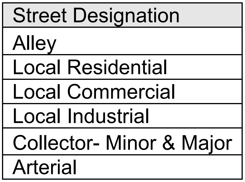
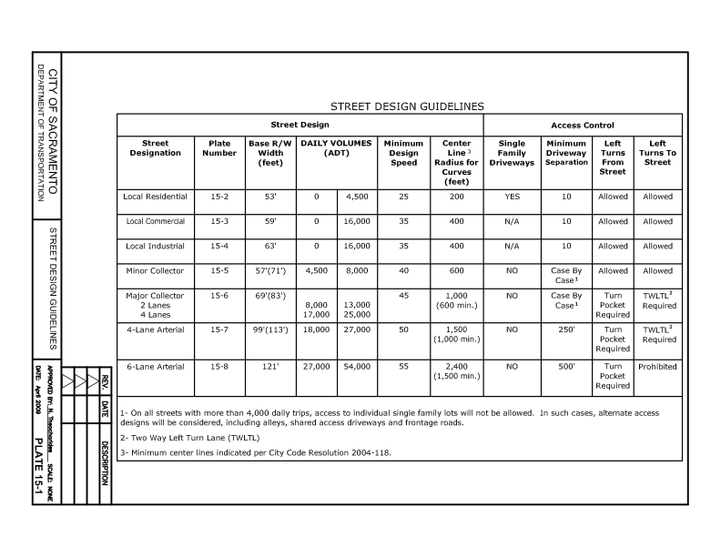
Defined in Chapter 15 of city Design and Procedures Manual, Sacramento’s current street typology hierarchy was last updated in 2009 and comprises seven typologies:
This hierarchy is somewhat different from but based on the state/federal Functional Classification System (FCS). The primary criteria of both is the speed and volume of motor vehicle traffic. It does not consider the place-based function of roadways, nor the requirement of safety for all users.
We at Strong SacTown believe that systems like the FCS and those based off of it must be rejected, and replaced by a typology hierarchy that recognizes the function of streets for place-making and access. We will always need some roadways which serve the need for longer distance and somewhat higher speeds, but those roadways should be a minor part of the transportation network. Freeways carry longer distance and higher speed motor vehicle traffic, but should not be present in urban areas, and are not the responsibility of the city.
To fulfill the city’s Streets for People goal and the 2040 General Plan (especially M-1.2 and M-1.5), streets must be designed or redesigned in a way that sets a different vision for the purpose of streets.
Stroads
The word “Stroad” entered the local Sacramento lexicon in April of 2022:
- Road: A connection between two places. Mobility is the focus, traveling distances at speed.
- Street: A platform for building community wealth. Access is the focus, connecting people to the most destinations with the least distance.
- Stroad: A street/road hybrid.
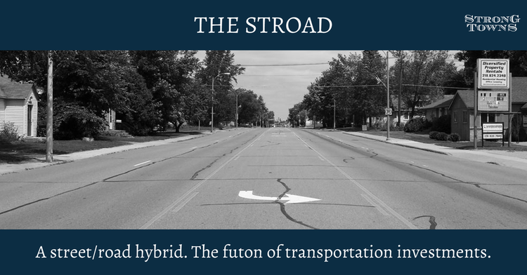
Stroads fail because they compromise both functions. They are designed for speed, yet are unsafe because they also serve the function of streets, which is access. The city has designed a significant portion of our roadway network as stroads. Most of the high-injury network identified in the Vision Zero Plan are stroads. Stockton Blvd is a stroad, a road designed for higher speed but with businesses, driveways and intersections which make those speeds unsafe. Stroads are dangerous, and they fail to effectively serve either mobility or access.
These stroads should be redesigned as either a road (which means reducing access and complications such as driveways), or a street, which means slowing motor vehicle traffic significantly and making the street safe for all users.
Strong SacTown’s Proposed Street Typologies
To help support the design or redesign of stroads into either streets or roads, and to enhance the comfort and safety for all road users, we recommend a new, simplified street typology:
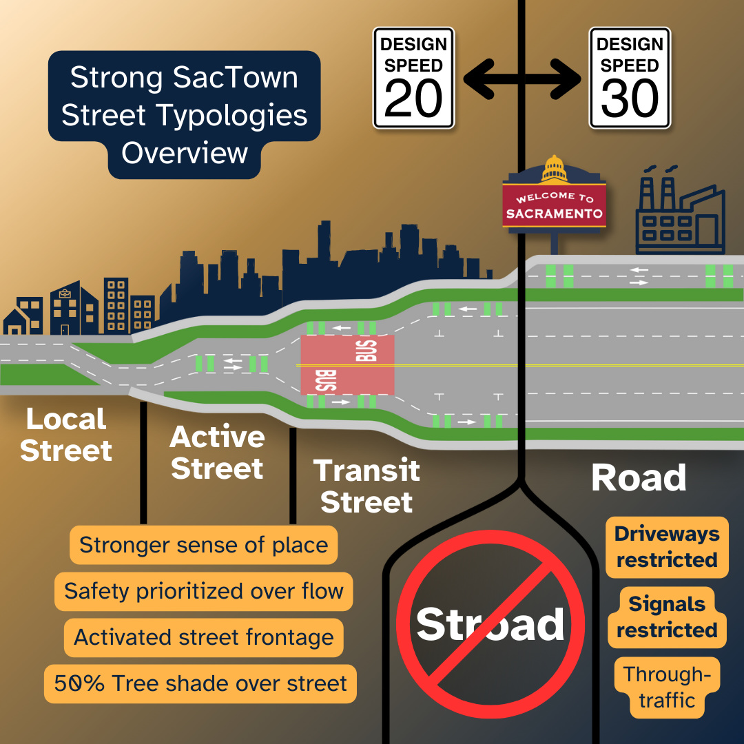
In lieu of Sacramento’s current seven typologies, ours comprises only four: Local Street, Active Street, Transit Street, and Road.
- Local Streets are the core of our street network, serving a built environment with multiple uses where most of the home, work, commercial and social needs of people are within walking or short bicycling distance. Motor vehicles are guests, safety is primary, and economic and social vibrancy are promoted. Some local streets may have no private motor vehicle traffic at all, or such use be limited to certain times of day. A majority of roadways in the city should be local streets. Local streets will have a maximum design speed of 20 mph.
- Active Streets have features that allow bicyclists and mobility device users to travel at somewhat higher speeds over somewhat longer distances. However, the local street function is not compromised. Active streets will have a maximum design speed of 20 mph.
- Transit Streets have features that allow effective transit use including higher frequency buses, streetcars and possibly light rail. However, the local street function is not compromised. Transit streets will have a maximum design speed of 20mph for streets with transit priority and 30 mph for exclusively transit.
- Roads are designed to allow longer distance travel at somewhat higher speeds, by transit and private motor vehicles. The safety of all users is still paramount. Roads should be a minor component of the transportation network, occurring at intervals of one to two miles. Roads will have a maximum design speed of 30 mph.
The city prima facie speed limit, used on streets on which there is no posted speed limit, will be 20 mph. All speed references are to design speed, the speed at which the street is safe and comfortable for all users. Normally, the design speed of a city street is higher than the posted speed limit, but under our proposal the speed limit must be consistent with the design speed.
While we recognize that streets will vary by place within the transportation system and the surrounding built environment, having a simple topology to remind that streets serve a purpose that is only partially travel or mobility, is important. Context-sensitive solutions must always be applied but we caution against creating overly-elaborate and prescriptive regulations such as those now being reformed in planning and zoning codes across the country.
Each of the four street typologies will be further defined in subsequent posts with diagrams, examples, and cross-sections. The objectives and methods of redesigning or healing existing roadways will also be a series of posts.
See also
- NACTO Urban Street Design Guide (2013, ISBN: 9781610914949). The NACTO Urban Street Design Guide provides a number of examples of how streets that were designed primarily for motor vehicles can be changed or healed to serve all users. Those diagrams, descriptions, and case studies should be used by the city when redesigning streets for better function and safety.
- Street Design Guidelines, City of Sacramento 2009 Street Design Standards
- City of Portland, 2035 Transportation System Plan
- City of Detroit, Streets for People Detroit Street Design Guidelines (2021)
Leave a Reply